How GIS Works
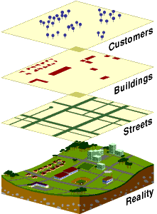
A GIS stores information about the world as a collection of thematic layers that can be linked together by geography. This simple but extremely powerful and versatile concept has proven invaluable for solving many real-world problems from tracking delivery vehicles, to recording details of planning applications, to modeling global atmospheric circulation.
Geographic References
Geographic information contains either an explicit geographic reference, such as a latitude and longitude or national grid coordinate, or an implicit reference such as an address, postal code, census tract name, forest stand identifier, or road name. An automated process called geocoding is used to create explicit geographic references (multiple locations) from implicit references (descriptions such as addresses). These geographic references allow you to locate features, such as a business or forest stand, and events, such as an earthquake, on the earth's surface for analysis.
Vector and Raster Models
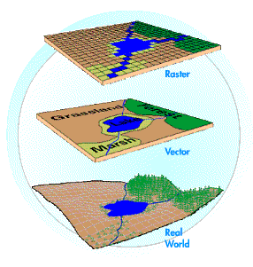
Geographic information systems work with two fundamentally different types of geographic models--the "vector" model and the "raster" model. In the vector model, information about points, lines, and polygons is encoded and stored as a collection of x,y coordinates. The location of a point feature, such as a bore hole, can be described by a single x,y coordinate. Linear features, such as roads and rivers, can be stored as a collection of point coordinates. Polygonal features, such as sales territories and river catchments, can be stored as a closed loop of coordinates.
The vector model is extremely useful for describing discrete features, but less useful for describing continuously varying features such as soil type or accessibility costs for hospitals. The raster model has evolved to model such continuous features. A raster image comprises a collection of grid cells rather like a scanned map or picture. Both the vector and raster models for storing geographic data have unique advantages and disadvantages. Modern GISs are able to handle both models.