
Data for GIS
What Map Data Do I Need?
 If you are unfamiliar with map data, think first about how you
want to use map data. Many project needs are met with the following
common map data types. Then explore these links to learn more
about map data!
If you are unfamiliar with map data, think first about how you
want to use map data. Many project needs are met with the following
common map data types. Then explore these links to learn more
about map data!
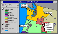
Base Maps--Include streets and highways; boundaries for census, postal, and political areas; rivers and lakes; parks and landmarks; place names; and USGS raster maps.
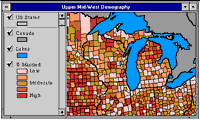
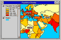
Business Maps and Data--Include data related to census/demography, consumer products, financial services, health care, real estate, telecommunications, emergency preparedness, crime, advertising, business establishments, and transportation.
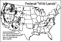
Environmental Maps and Data--Include data related to the environment, weather, environmental risk, satellite imagery, topography, and natural resources.
General Reference Maps--World and country maps and data that can be a foundation for your database.
How Do I Get Map Data?
Fortunately, volumes of existing geographic data are readily available.
Through the ArcData Publishing Program, ESRI has established a
partnership with leading commercial data vendors to provide a
wealth of information in a plug-n-play format for use with ArcView
GIS. ESRI's GIS Store and ArcData Online both offer a convenient
way to get the most popular geographic data.
And, a variety of useful geographic data come bundled with ArcView GIS to help you get started quickly.
These data sets can be used as the foundation for your GIS projects or to supplement your existing data.