
What Is a GIS?
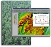
A geographic information system (GIS) is a computer-based tool for mapping and analyzing things that exist and events that happen on earth. GIS technology integrates common database operations such as query and statistical analysis with the unique visualization and geographic analysis benefits offered by maps. These abilities distinguish GIS from other information systems and make it valuable to a wide range of public and private enterprises for explaining events, predicting outcomes, and planning strategies.
The major challenges we face in the world today--overpopulation, pollution, deforestation, natural disasters--have a critical geographic dimension.
 Whether
siting a new business, finding the best soil for
growing bananas, or figuring out the best route for an
emergency vehicle, local problems also have a
geographical component GIS will give you the power to
create maps, integrate information, visualize
scenarios, solve complicated problems, present
powerful ideas, and develop effective solutions like
never before. GIS is a tool used by individuals and
organizations, schools, governments, and businesses
seeking innovative ways to solve their problems.
Whether
siting a new business, finding the best soil for
growing bananas, or figuring out the best route for an
emergency vehicle, local problems also have a
geographical component GIS will give you the power to
create maps, integrate information, visualize
scenarios, solve complicated problems, present
powerful ideas, and develop effective solutions like
never before. GIS is a tool used by individuals and
organizations, schools, governments, and businesses
seeking innovative ways to solve their problems.
Mapmaking and geographic analysis are not new, but a GIS performs these tasks better and faster than do the old manual methods. And, before GIS technology, only a few people had the skills necessary to use geographic information to help with decision making and problem solving.
Today, GIS is a multibillion-dollar industry employing hundreds of thousands of people worldwide. GIS is taught in schools, colleges, and universities throughout the world. Professionals in every field are increasingly aware of the advantages of thinking and working geographically.